
About the Archive
The role of the Digital Heritage Research Group at the University of Calgary is to serve as “technicians of remembrance” . We do not lead – rather we are guided by the communities we collaborate with.
Why Digitally Preserve Heritage?
The Alberta Digital Heritage Archive is one of three online archives dedicated to the digital preservation of heritage at risk. The archive was created by Dr. Peter Dawson in 2017 with funding from the Mellon Foundation. Our mission statement focuses on the preservation and protection of heritage sites in the Province of Alberta that are at risk of destruction due to the impacts of climate change and human activity. Of particular interest are heritage sites that lack official designations or messages of significance from government agencies and heritage organizations. These are typically buildings, bridges, trees, and other forms of heritage that are of importance to local communities and individuals. While physical preservation is always preferable it is often not possible due to lack of resources. Digital preservation offers an alternative.
How does Digital Preservation Work?
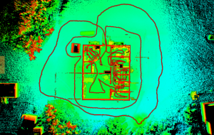
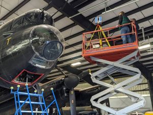
Digital preservation involves what are called “reality capture technologies” such as terrestrial and aerial liDAR and photogrammetry. Our research group relies primarily on laser scanning (liDAR) to digitally capture and document heritage sites. A laser scanner is analogous to a 3D camera. The instrument emits millions of points of laser light as it slowly rotates on two axes (X,Y). The instrument measures the amount of time taken for each laser light point to leave the scanner, strike the surface of an object within its field of view and return. This information is used to calculate each point’s x,y, and z coordinate in space. The result is a dense cloud of laser points (point cloud) that creates a 3D image of the object being scanned. Like a camera, a laser scanner can only capture what it can see. Therefore, the instrument must be moved around and through an object such as a building in order to capture it from all possible angles.
What can you do with a Point Cloud?
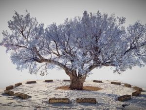
The spaces between individual points within a point cloud can be less than a millimeter in size. This means that extremely accurate and precise measurements can be take directly off a point cloud. As a result, it is possible to record the dimensions of doors, windows, rooflines, as well as calculate floor areas and other architectural measurements from the data. As many heritage buildings lack up to date architectural plans, point clouds allow researchers to create “as built” versions that can be used to repair or rebuild them should they ever be damaged or lost. Point clouds can also be used to virtually visit heritage sites that may otherwise be inaccessible due to their geographic location, unsafe conditions onsite, or because they have been lost. Physical models of heritage sites via 3D printing technology can also be created from point clouds. These “physicalizations” of heritage provide users with opportunities to touch, feel, and hold in their hands scale versions of heritage buildings, trees and other objects.
What is in the Archive?
The Alberta Digital Heritage Archive contains a wide variety of cultural, natural, and even biological heritage objects/sites – many of which no longer exist. Each heritage object has its own project page consisting of an interactive point cloud or mesh model; background information about the history of the object and its significance to individuals and stakeholder communities; a photo gallery of historic and contemporary images; a map showing its location (where appropriate); information about how the object was digitally captured; and videos and computer animations. Some project pages also contain added features such as virtual tours, panoramic images, and “before and after” viewers that allow you to compare historic and contemporary images of landscapes and heritage features. A Data Files tab allows users to download scanning data for research purposes when appropriate.
Perhaps the most important area of the archive is where the scanning data for each heritage object is stored. Borealis, the Canadian Dataverse Repository, is a bilingual, multi-disciplinary, secure, Canadian research data repository, supported by academic libraries and research institutions across Canada. Borealis supports open discovery, management, sharing, and preservation of Canadian research data. All of our heritage data is securely stored within Borealis and PRISM Data – a research data repository for UCalgary faculty, students, and staff. This ensures that the digital heritage data contained within our archives will be preserved for future generations.
What is Data Sovereignty?
The data contained in this archive is owned by a wide range of stakeholder communities and government agencies. While some have granted permission for their data sets to be “open source” and accessible to anyone, others have requested that access be restricted and by permission only. In the case of Indigenous heritage sites, we closely follow the First Nations principles of ownership, control, access, and possession (OCAP®) (https://fnigc.ca/).
Other Archives
Please check out our other digital heritage archives!
Qikiqtaruq/Herschel Island Digital Heritage Archive
Alberta Indian Residential School Archive
If you have any questions about the archive, please reach our to archive director Dr. Peter Dawson pcdawson@ucalgary.ca