
Alberta Buffalo Jump Site
“over the edge of which hunters used to drive the buffalo…and their bones still lie in places two and three feet deep” St. Maur, S. 1890. Buffalo jumps such as this are found scattered over the Plains of North America. Archaeological excavations took place at this site in 2015 and 2016 and recoveries include stone projectile points, along with metal trade points, and a glass trade bead, these material culture indicators suggest that the jump was used between 1725 to 1870 A.D., the continued use of which spans the period immediately preceding, during and directly following the first interaction between First Nations and Europeans along the foothills of southern Alberta. The Buffalo Jump site represents one of the greatest achievements of communal hunting to survive in harsh climatic conditions and recoveries from the excavations can be used to provide additional insight into cultural transformation during this dynamic period.
Region:
Southwest Alberta
Field Documentation:
September 13, 2017
Field Documentation Type:
Terrestrial LiDAR
Culture:
Blackfoot, Canadian
Historic Period:
2017CE
Latitude:
53.933271
Longitude:
-116.576504
Datum Type:
Threat Level
 Buffalo Jumps
Buffalo jumps such as this are found scattered over the Plains of North America, this jump is significant due to its direct link to traditional stories by the Blackfoot people’s. This buffalo jump was first recorded in 2015 during an assessment program undertaken on behalf of Alberta Culture and Tourism to evaluate the effects of widespread flooding in 2013. Archaeological excavations took place at this site in 2015 and 2016 and recoveries include stone projectile points, along with metal trade points, and a glass trade bead, these material culture indicators suggest that the jump was used between 1725 to 1870 A.D., the continued use of which spans the period immediately preceding, during and directly following the first interaction between First Nations and Europeans along the foothills of southern Alberta [1]. The Buffalo Jump site represents one of the greatest achievements of communal hunting to survive in harsh climatic conditions and recoveries from the excavations can be used to provide additional insight into cultural transformation during this dynamic period [1].
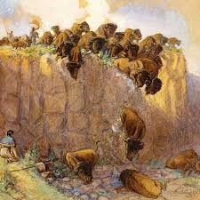
For thousands of years, the North American bison, or buffalo, were an integral aspect of the lives the Blackfoot people of the North American Plains, and the story of the buffalo jump is one of the great dramatic stories in the history of the world [2]. The North American Plains consists of a midcontinental grassland landscape that is a near barren, windswept land, with a semi-arid climate [3]. Every so often, a bedrock outcrop on the Plains grassland would lie in precisely the right location, and through construction of great features on the landscape, allowed for the right conditions for Blackfoot hunters to make use of them. The annual cycle of economic activity for the Blackfoot people centered on the hunting of bison, in using well-organized herding methods to efficiently hunt bison, buffalo jumps such as this were created on the Plains of North America. The ancestral Blackfoot people relied on communal hunting strategies, such as the use of buffalo jumps, to store sufficient food for the winter months [4]. This jump is significant due to its direct link to traditional stories by the Blackfoot at this location.
The Blackfoot demonstrated skill and cunning in their methods of rounding up these huge animals to drive them over the cliff. During the hunt the Blackfoot would gather the bison in the gathering basin and begin to lure the bison along the drive lanes constructed using piles of rocks, called cairns. The hunters would conceal their presence behind these cairn rock features set up along the drive lanes, sometimes for kilometers long, and then rise at the appropriate moment to wave robes, make sounds, and direct the animals over the cliff [4]. All of this cumulated to the finish line at the cliff, representing the moment when the thundering of the deadly stampede ended with an eerie moment of silence as the animals became airborne, followed by a series of thuds as the massive bodies of the buffalo slammed into the earth below [2].
The Plains were historically dominated by bison, and the depth of human creative solutions to survive demonstrates the astonishing triumph of intelligence to thrive in circumstances stacked overwhelmingly against them as is demonstrated with the buffalo jump [2]. Buffalo were more than just a food source for the Blackfoot people, the animals had an intrinsic value as their hide provided shelter, clothing, and bedding, and the bones could be made into tools [5]. Following the hunt, the process to create storable and transportable byproducts such as pemmican and hides immediately commenced [6], and a successful jump could mean the difference between survival and starvation during the long winter months [7].
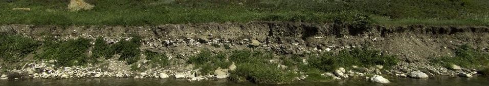
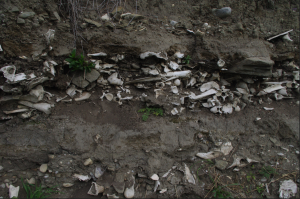
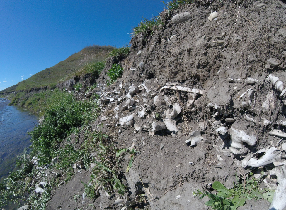
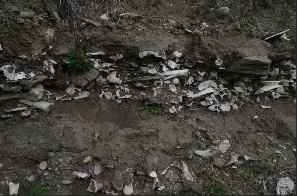
The bone layers are apparent in the cutbank and represent the repeated use of the site as a buffalo jump over time. Given the time and energy invested in modifying the landscape, the hunters would re-use a locale, and this further emphasizes the spiritual and historical attachment to this place [4].
The specific buffalo jump depicted in this model has been associated with the ancestral Blackfoot peoples [1]. Pis’kun is the Blackfoot word for a buffalo jump or pound, and strong evidence supports that this buffalo jump represents the traditional location of the site has most notably been referred to as the “Men’s” pis-kun [1, 4] Evidence for this is further provided by the Stoney Nakoda name for the Jumpingpound creek translating to “place where Blackfoot camped River”. Additionally, this site locale appears to be tied to the Blackfoot during the Proto-historic Period based on interpretations of material cultural remains from archaeological excavations [1].
The artifacts left at a kill site are the material correlates of behaviors that offer new insights into aspects of communal hunting practices and changes over the period use of this site [4]. Metal points were recovered in each cultural unit of the excavations, and the Blackfoot people are known to have acquired metal through trade between 1730-1740 A.D., and bison are known to have been extirpated from the area by 1880 A.D., providing the estimated period of use of the jump at the age of 1735-1870 A.D. and radiocarbon dating at this site was undertaken on the archaeological remains of the site further confirmed this age range. These results place the use of this site is during the Protohistoric through to Historic period, just prior to direct and sustained European contact in the area around the 1870s [1].
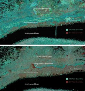
This flooding, categorized as one of the worst in the province of Alberta’s history, caused the change in watercourse of the Jumpingpound Creek to expedite natural erosion processes at the site. The site was identified by archaeologists in 2015 and was determined to be at immediate and ongoing risk of additional flood-related impacts [1].
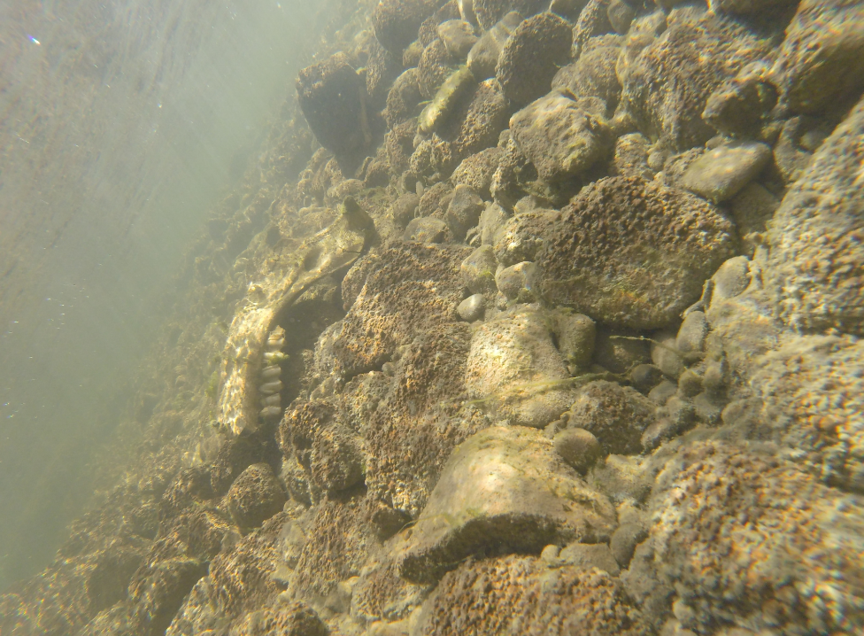
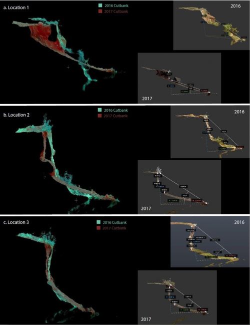
This means that significant information relating to the jump may have been lost during the flood event. Results of the comparison of the scanning data collected in 2017 further demonstrates that ongoing erosion processes are impacting the site and its resources following the initial flood, with up to 1.5 meters of erosion having taken place in certain areas of this site locality between September of 2016 and 2017. The bone beds, as well as the remains of the nearby camps and processing areas, which contain the remains associated rituals and actions at this location [4], are threatened by erosion. The significance of this resource in its connection to the history of the local Blackfoot people deem it absolute necessity to ensure continued research into technologies that can contribute to the maintenance and preservation of this resource.
References
[1] Leyden, Jeremy .J. and Landals, Alison. 2017 The Wearmouth Buffalo Jump: A stratified protohistoric site on lower Jumpingpound Creek, Alberta. Archaeological Survey of Alberta Occasional Paper No. 37: 58-72.
[2] Brink, Jack W. 2008 Imagining Head-Smashed-In: Aboriginal buffalo hunting on the northern plains. Athabasca University Press, Edmonton, Alberta.
[3] Kay, M. 1988 The Great Plains Setting. In Archaeology on the Great Plains, edited by W.R.Wood, pp. 16-47. University Press of Kansas. Lawrence, Kansas.
[4] Oetelaar, Gerald.A. 2014 Better Homes and Pastures: Human Agency and the Construction of Place in Communal Bison Hunting on the Northern Plains. Plains Anthropologist 59(229): 9-37.
[5] Ewers, J.C. 1958 The Blackfeet: Raiders of the Northwestern Plains. University of Oklahoma. Norman, Oklahoma.
[6] Zedeño, M. N., Nieves, M., Ballenger, J. A.M., and Murray, J. R. 2014 Landscape Engineering and Organizational Complexity among Late Prehistoric Bison Hunters of the Northwest Plains. Current Anthropology, 55(1): 23-58.
[7] Frison, G. C. 1978 Prehistoric hunters of the high plains. Academic Press, New York.
Capture Technologies
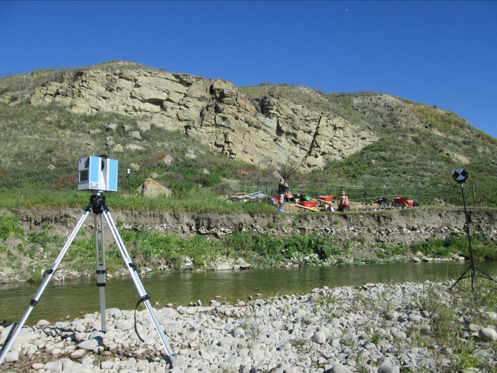
Terrestrial laser scanning (Ground-based LiDAR) was conducted at this site to digitally document the Buffalo Jump, and data was conducted using a Z+F 5010X laser scanner set-up in 11 different scan positions around the site. The scanner collects point data in 360° at a distance of up to 130 meters and emits a pulse of laser light that records a ‘scene’ of an archaeological site. The instrument measures the “time of flight” to record the time it takes for the beam to strike a surface and return to be recorded. The rotating instrument head and mirror calculates the horizontal and vertical angles of the pulse to provide accurate X,Y and Z coordinates for each point. Millions of light beams are emitted and recorded during each scan, and this creates a dense three-dimensional cloud of points that forms the shape of the ‘scene’ in ‘view’ of the instrument, represented in a point-cloud. 11 scans were captured at the site and then registered together to produce a single point-cloud dataset containing accurate and high-resolution spatial data. Initial scanning of the site took place September 15, 2016 and a second set of scans was collected one year later, on September 30, 2017.
The point cloud data collected was processed and analyzed at the University of Calgary’s Digital Heritage Laboratory in the Department of Anthropology and Archaeology. Z+F Laser Control software was used to register the datasets together and create a completed point cloud. Autodesk ReCap was used for visualization and enhancements of data, and to view point-cloud data as accurate and photo-realistic models of the site.
Erosion Monitoring
Continued erosion monitoring took place at this site as terrestrial LiDAR point clouds were captured in 2016 and 2017 with 11 scanning locations around the site and cutbank exposure. The two scanning datasets were then overlaid using CloudCompare software to examine how much erosion took place. The results of this are displayed in Figure 1. The LiDAR scans captured from the far side of the bank provided a view of the undercutting of the bank. This allowed for examination of areas of severe undercutting to predict where slumps and expedited erosion may occur, as seen overlaid in Figure 2. Estimations of bone density based on the excavations as compared to the analysis of the change documented by the 3-dimensional dataset indicates that over 25,000 bones may have been displaced between 2016-2017 as a result of continued erosion at the site.
Scan Locations
